NASA has posted data showing record melt areas covering the entire Greenland Ice Sheet from July 8-12. http://www.nasa.gov/topics/earth/features/greenland-melt.html
July 12, 2012
Ive been sick the past few days, but luckily the action has been in town this week. The Watson river is the major waterway that funnels though the spillway at the edge of town. Over the past couple weeks we have been noting the height of the river, but nothing compared to the water flowing though the spillway on Tuesday July 10th. I took a series of videos and photos over July 10-12 (today). The bridge across the spillway is also the only way to reach the other side of the river (unless you have a helio...). The town water supply, routed over the spillway from Lake Ferguson, is also threatened by the river as it flows over the main piping.
Today, July 12th, the bridge is impassible, with the center and far southern side completely eroded out by raging brown water. Some folks said this is the highest they have seen the river in the 40 years they have lived in Kanger. The water started rising rapidly on a clear, sunny, windy day. Hydrologists familiar with the area have noted that the watershed for the Watson river is massive, extending up to Summit and the ice sheet divide. What can I say folks, the ice sheet is melting...
Some Geographic context:
The Watson River Spillway at low water, Note the two Bridge trusses in the photo, The rock splitting the river downstream of the bridge is covered by rapids. The road sections between and south of the two trusses are completely eroded. You can just see the main water supply piping running along the right side of the bridge; its now submerged.
The Watson is fed by two converging, major rivers: one that flows from the Russell and Levit (I believe ?) Glacier, the other that flows down the Desert Valley (where Karen and I did the 40 mile hike). Discharge from the Levit glacier was twice the expected seasonal outflow. Water from the Watson is constricted at the spillway and widens again before flowing to the Kangerlussuaq Fijord. Kanger Fijord is the 3rd largest fijord in the world! During the high water event, discharge through the spillway was estimated at 15 billion L/sec. Over the duration of the high water event (est 15 hrs), as much water passed through the Kanger spillway as Denmark consumes in a year.
July 18, 2012
Today, the water has receded significantly. During the event the town's water supply pipe covering was ripped to shreds but the pipe was spared!
Some photos and videos:
Before (6/29/2012):
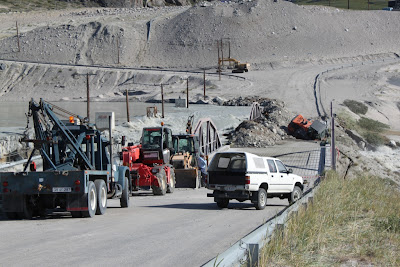
July 10, 2012, around 6pm, water is getting dangerously high and flowing over the town water supply pipe. Earth-movers begin to reinforce the fill between the bridge sections and the road.


Water is beginning to overflow the spill way bank.
July 10, 2012 around 9pm,
water is beginning to top over and erode the center fill section. The water pipeline is submerged.

July 10, 2012 around 9pm,
water is beginning to top over and erode the center fill section. The water pipeline is submerged.

July 11, 2012 ~ 5:30pm
Earth-Mover has fallen into a sinkhole in the center fill section of the bridge. The driver made it out!
Looking up stream, Right hand section of bridge
Looking up stream, Left hand section of bridge
upstream of bridge, note the structure meant to divert water in the center of the river is completely submerged
July 11, 2012 around 10 pm
July 12, 2012
The water diversion structure upstream of the bridge re-emerges with the new channels distributing the water. Three other diversion structures were washed downstream and sit in a large sediment deposit today (July 24, 2012)


No comments:
Post a Comment