Saturday, September 17, 2011

Ice cave - ice block sampling


I brought my crampons and ice axe on our final ice cave/cliff trip.  Turns out, if I wear two pairs of "summit" socks in the size 9 Job Master rubber boots they can take universal crampons pretty well!  In fact, they become "slip-on crampons."  Somehow I don't think the notion of slip on crampons is going to take off ;) ...but it served its purpose.  I kicked my way up the rocky permafrost behind the half frozen waterfall.  My axe bit into the ice above the waterfall well enough (better than expected for a general purpose ice axe!) that I could work my way into the ice cave above.  Above the waterfall the permafrost disappeared.  I stood in a chamber of ice.  The cavern walls glowed a faint blue.  On the floor of the chamber was an ice covered catchment with a small deposit of rounded stones in the bottom.  The image was something like an icy, zen rock garden with water silently flowing beneath the smooth, window-like ice surface and around the submerged rocks before remerging and flowing over the waterfall…I soaked it in…then, I destroyed it all.  For the sake of continuing on into the ice cave, I had to punch through the cm thick ice film in order to find footing on the cavern bottom.  This is where the slip-on job-master rigged crampons excelled, dry feet and solid footing!  Now the water was flowing freely though the cavern, no more serene blue zen-gardens.  I sort of crashed my way through the calf high icy waters, ducking around the turns and hugging the cavern walls to avoid the deepest parts of the pools.  A couple turns in the cavern narrowed and the water became too deep for my boots.  I strained to see around the next bend but could not determine how far the cave continued.  Ron took a turn with the crampons and made it past the place where I stopped.  He managed by pulling what I understood to be a chimney move, over the deep pool and through the narrow passageway; a move I considered but decided to forgo…apparently the cave ended shortly thereafter.  In retrospect I should have given the chimney move a chance!  

By that point we had moved on to taking ice core samples with an ice screw.  It’s really quite a brilliant way to collect a point sample from an ice layer!  For those folks unfamiliar with ice screws, they are open cylinders that are threaded about half way up the shaft.  “Teeth” in the end of the screw help it set and cut the ice as you screw it in.  As the screw penetrates the ice, the ice inside the screw is pushed out the back, where we collect it in a bag.  The screws are made for ice climbing protection, i.e. for clipping a climbing rope into…but they work great for collecting point samples in an ice profile.  We also used a chainsaw to collect three large basal ice blocks from the canyon walls…and nabbed a layer of clear, frozen runoff for whiskey drinking… all total, we probably carried back about 140 pounds of ice.  

Monday, September 5, 2011

4 days left

We finished up the days work at 10pm. Or we atleast called it quits, more sample analysis in the morning... I should be editing my first paper for publication, but since my brain is fried, screw it...so I'll take a few to give some updates.


Two of the Principal Investigators arrived just over a week ago, and since the transition its been go go go!  We have been racing to all of our regular sample sites (5 total: Vortac, Shelter 7, Ice cliffs, North River Bridge and Tuto)  and Ron has employed my help with some GIS work.  Most days start when we wake up around 7 or 8am.  You can usually find one of us in the lab, in pajamas, calibrating the pH meter or sterilizing buckets, with a coffee cup just an arms reach away...we drink A LOT of coffee.  Many of the past days have seen me in the lab until 9pm. and tonight 10pm...did I mention we drink A LOT of coffee?  Cest la vie!  I think the bio-team will have samples just finishing up at midnight tonight. 


...the reality is, I really can't complain too much... today was an Ice Cliff day.  The Ice cave we sample from has become a proper slot canyon.  The glacial runoff cut through the ice and permafrost, creating a snaking chasm that exposes the junction between basal ice and glacial till.  The water is low enough that you can walk into the canyon with rubber boots.  The ice walls are vertically striated with ribbons of ice that protrude from the surface.  These form as melt water drips from the surface, taking a tortuous yet consistent path down the vertical ice.  Each drip freezes in layers along the thin ridges slowly building them up.  Some of these ridges extend 4 to 5 inches out from the wall!  Beneath the ridges and a 1 inch vernier of crystal clear melt-water ice is the true glacial ice.  The glacial ice glows a faint, bright blue.  Horizontal bands from thousands of years of snow and ice deposition meander their way along the water sculpted walls.  In one section you have to double over to pass beneath two lobes of ice before the canyon opens up again.  In the back of the cave a waterfall drops 3 feet into a small plunge pool.  Above the falls the canyon becomes a proper ice cave, a bright blue tunnel extending deeper into the ice sheet...I'd venture into the tunnel, but this requires a combination of waterproof footwear and crampons...so, mom, its ok, I just don't have the gear...yet. ;)...ice features are quickly climbing my "most beautiful places" list.


Highlight numero dos! A couple weeks ago I held a peregrine falcon fledgling in my bare hands.  I got a little talon action, we're blood sisters now.  But really, it was an amazing experience.  The "bird guys" (ornithologists if you want to be technical) invited us to join them on thier last mission of the season: retrieve, measure and band the falcon fledglings nesting on the cliffs of Dundas Mt.  One of the guys rapelled down to the falcon nest and sent the birds up, one by one, in a yellow haul bag.  Mama and Papa peregrine were freaking out, flying circles around the cliffs.  It was a non stop racket from the time we approached the cliff top, until we left.  The fledglings were estimated at 25 days old.  White and fluffy, they crouched in a backpack corral, staring up at us with piercing black eyes and screeching at the top of their lungs.  The two females looks legitimately pissed, the male looked sheepish...just saying :).  The bird guys measure the fledgling wings and legs, attach a stylish, numbered ankle bracelet, take a blood sample and pluck a few feathers.  The blood will be used for isotope analysis to get information on the birds' diet.  Once all the research was done we all got a chance to hold one of the fledglings.  The fastest animal in the world feels fragile in your hands.  Beneath the soft, puffy feathers and tough chick attitude are thin, delicate bones and sinews.  Also of note: Peregrine breath is distinct...it reaks. And, David, birds do fart.  They would let one slip after a torrent of angry screeching.  It was pretty hilarious.

Sunday, September 4, 2011

Ice Cliffs (8.14.2011)

Ice Cliffs (8.14.2011) - Our second, weekly sampling site is named ice cliffs or ice cave.  We sample the clean blue water that drains from the top of the ice sheet, flows down through the terminal moraine and out an ice cave, before dumping into North River.  The hike from the road is about 1.5 hrs over glacial till and tundra scrub.  We cross two rivers on the way; one of which I have yet to traverse without getting water down my boots.  I’m borrowing a pair of size 9 rubber boots that are loose on my feet and calfs.  I often take along my hiking boots and change into the rubber boots for river crossings…  But, my feet get soaked in the rubber boots anyways, either because I’ve stepped in a hole or deep channel in the river, or splashed water down the tops just in the course of walking.  Now I just plod along the whole 1.5 hr hike in my big rubber boots with wet socks (wet socks are warmer than no socks!).  Changing socks and boots gets tedious.  I’ve got this nice little rhythmic shuffle down.  
The water in the rivers we cross is cold, 2 deg. C.  Laura and I choose a less than ideal place to cross one day and my large boots filled half way with water.  With no socks on, my feet were in pain from the frigid pools in my boots.  I even stopped mid river to dump them out!   Laura and I were cracking up…oh duh, this is why we don’t ever cross here.  
After the river crossings we hike up a small valley that cuts through the terminal moraine and head south along the ice to the ice cave.  The ice cave is a cut in the terminus of the ice sheet that is scoured out by cold glacial runoff.  We cross North River, which runs parallel to the ice front, to reach the mouth of the ice cave.  There is a stark contrast between North river, a turbulent, sediment heavy flow, and the smooth clear blue ice cave runoff.  I’ve collected 20L and multiple small samples from this ice cave flow, each time the water chilling my hands to the bone within seconds.  The water is 0.1 deg. C.  If you fall in, you would have very little time before becoming hypothermic.  Our waders allow us to cross the rivers comfortably; it’s a fun feeling, freezing water compressing your legs through the waterproof overalls, and all you feel is a nice cooling effect.
The cave changes each week we visit, morphing from a cave into a canyon, its walls and roof slowly widening.  The ice walls are a glistening blue and white, scalloped and sculpted into a snaking canyon that narrows into a tunnel at the back.  

On one occasion I donned my crampons and hiked up a sloping ice ramp, working my way up the terminus of the ice sheet.  Runoff rivers snaked through the ice and funneled into the ice cliff’s canyon.  Many of these rivers had a pulsing flow.  Plugs of water would periodically disrupt the steady stream flow, gushing down the frozen, luge like channels.  From the terminus you can easily continue east onto the white expanse of the ice sheet.

Sunday, August 7, 2011

Fieldwork, every day!


Ok, the People!  I’m here helping out a collaboration that includes Ph.D.s : Ron Sletten (UW, geochemistry), Birgit H. (U Alaska, geochem.), Karen Junge (Principal Investigator, UW, microbiology) and Brent (U. Louisiana, microbiology).  Right now, there are five of us here: Lu and I (grads, under Ron), Laura (undergrad, under Karen), Kyla (grad, under Birgit) and Markus (post-doc, under Brent).   Kyla and Markus both have research goals dependent on the sampling and research being conducted.  Laura, Lu and I are here to help, contribute our knowledge and get some field experience.   It’s certainly a fun group to hike with during the day and hang out with in the evenings!
 Aside from sampling, and typical sample processing, I’ve contributed by getting a high purity water filter up and running.   The water purifier makes ridiculously clean water for use in the iron analysis chemistry, etc.  It connects directly to the water faucet and pumps the water through a series of purifiers.  When the purifier tank is full, however, the pump shuts off and pressure builds in the tube…so much so that the tube exploded, or, if caught in time, it looks like a huge balloon and sprays out from the hose clamped connections…not so ideal.  So I made an overflow outlet in the main water supply tube with a pipette tip and additional tubing.  This eliminates the pressure issue. WIN.
I’m also helping trouble shoot the iron analyses and managed to make an anerobic (no Oxygen) Fe(II) standard.  Turns out, three years as a lab rat makes you useful to field monkeys J 
The research!  The goal of the research is to look for a link between cryophiles (cold loving microbes!) and chemical erosion under glaciers and the ice sheet.  Microbes are ubiquitous in the environment, and are even found in ice.  The idea follows that microbes living in and beneath the ice sheet may be promoting, and perhaps speeding-up, chemical erosion rates.  i.e. dissolve rock!  Microbes can do this in a couple ways:  1)by metabolic processes where they actually “eat” rocks for an energy source (aka chemo-litho-autotrophs); 2.) by releasing organic compounds that break down the rock; or 3.) perhaps, simply by their physical presence, that is, their surfaces interact with dissolved ions which may affect the rate at which minerals are chemically eroded (don’t think too hard about it, I skipped a lot of steps/explanations in this one, I’d be happy to tell you more if you want it!)

Why do we Care!?  The goal is to learn more about how microbes can affect the transport of major ions and elements in cold regions.  Major ions such as iron act a nutrients in the oceans while others such as calcium plays a part in limestone formation and CO2 cycles. 
So, we need to find and sample sub-glacial water flow and compare it to surface melt water.  In both of these sources they will analyze the microbial communities and water chemistry and try to determine links between the two.  The surface melt water part is easy… too easy…its sunny 24 hours a day, resulting in extensive snow and ice melt.  North river runs parallel to the ice sheet, and is flowing with such force that you can hear boulders trundling down through the rapids (class 2-3?).  We have no reason to believe that any of the smaller streams issuing from the ice sheet are true sub-glacial flow.  Hopefully colder weather in late august will reduce the melting and reveal some promising sub-glacial springs.

The field!  I’ve been in the field every day.  We have two weekly sample sites and some additional locations that we monitor every other week.

Vortec : 2x weekly sampling.  We take a side road that “ends” at a military radio/satellite/who-knows-what station that we call “the bowling pin”… unless we are lazy, then we keep driving over the glacial till and tundra until it gets too bumpy and rutted.  The hike, even from the bowling pin, is only about 30 minutes, but the rocks, ice and terrain are remarkable.   The glacial till challenges every step with loose ankle-breaker sized rocks.  After only a couple weeks here you begin to appreciate the size of rocks and what it means for your footing.  Smaller or bigger rocks, no problem, but the fist to head sized ones, watch out!  90% of the terrain here is covered by the “ankle roll” range, and it really slows things down!  As you approach the ice cliffs a large sandstone formation appears.  Wide, perfectly preserved ripple marks run along dislodged slabs of copper colored sandstone.  Symmetrical ridges on the ripple marks tell us that a large lake once shaped sandy shores in this part of Greenland.  The sandstone lies atop a black shale deposit that is flaking away along the edges of a 20 ft deep drainage cut.  We hike down into the drainage and towards the valley cut by the North River.  North river is bound by the terminal moraine of the Greenland ice sheet, glacial till and black shale cliffs.  Towering ice cliffs loom over our sampling site.  Blue and brown layers within the ice form elaborate horizontal banding patterns while waterfalls drain from the top of the ice sheet, cutting bright blue channels or leaving vertical mud deposits.  Rocks fall from the ice cliffs every day.  We see them bounce down channels and slide off ledges crashing into the river below.

There is a glacial outflow about 500 feet north of where we sample… but with the combination of shale and ice cliffs and, fast moving, deep water, we cannot get to it.  Today (Aug 5th) Markus and I went on a scouting hike, with an end goal of sampling the outflow channel visible from Vortec.  It took us about 5 hours, round trip, to reach the outflow and sample it.  We had to hike north from where we parked our F-350 (oh, and I get to drive and F-350 a lot, its fun when you aren’t paying for the gas…or thinking about the pollution it produces) to find a suitable place to cross the river.  I have a bit of a mass problem when it comes to crossing fast moving water, I just don’t have enough of it, so Markus gave me a hand.  We crossed the river up-stream of several large inputs.  

We work along an ice front that seems to be a lobe of the ice sheet itself.  This might be in contrast to a glacier, which extends from the ice sheet and weaves its way down a valley or between mountains.  (glaciologists, correct me if I’m wrong in this distinction!)  Fingers of ice form sloping ridge lines that reach out from the ice sheet lobe.  In some places these ice ridges are cut by the river resulting in ice cliffs.  Others have their own melt water tributaries that dump water into the North River, drastically increasing the flow downstream.  We crossed one of these tributaries by traversing the ice around the mouth of the outlet.  There is a fair amount of gravel embedded in the ice along with a crusty layer of snow and slush that supplies some grip for boot treads.  We crossed sans crampons.  We continued along the terminal moraine, crossing many small melt tributaries.  To get to the outflow just north of Vortec we had to cross one last ice ridge.  We climbed to the top in our boots…a bit tricky as I found a very wind scoured patch that was solid, slippery ice, if you fell you would slide about 20ft to the bottom, not the end of the world, but not a nice prospect.  At the top we found that the ridge was not so symmetrical and dropped off rather sharply on the other side…we aren’t ice climbers :)… So we went back down the way we came, donned the waders and waded along the small ice cliff.  We finally reached the outlet we had set out for and set up shop on the rocky shore.  I choose to toss my gear below the main drainage path since there were rocks, some the size of baseballs and footballs, falling from the ice cliffs just upstream of the main drainage.  As I was sitting there filtering out the samples, Markus noticed a new, thick flow of muddy water issuing from the top of the ice sheet and running down the dirt encrusted ice drainage.  OK, not a good place to filter!  We quickly moved our equipment away from the drainage path… and into the rock fall path, great.  Mental note,  NEXT TIME, PACK A HELMET! Duh.  

Sometimes, lakes and pools on the ice sheet can suddenly drain.  We have to watch out for these events in case we are in the river or near the meltwater outflows.  We may have witnessed a small event when the muddy water started running down the drainage.  We got out of that place a quickly as possible, happy to be away from the falling rocks and water flows.  The hike back included a couple tricky river crossings but, fortunately, nothing too exciting.
There is so much going on here it’s hard to keep up with posting!  I find I am not tired until I am exhausted!  Next round I’ll fill in details on the other sampling sites and our camping trip: eating homemade quiche and sleeping on the beach, in a spectacular fjord where three tidal glaciers dump ice bergs into the icy waters.  Rad.
Also, thanks KP for posting info about the flora photos and correcting my usage of Moulin!  I guess that sample location is just an ice river…we’ve dreamed of epic dry-suit tubing down those snow/ice fields :)

Saturday, July 30, 2011

 AF base,Thule.  The boxy buildings are housing...sorry its so small!
 wildflowers!


 hiking...I forget where.  This is what much of the landscape looks like
 The hike down to Vortec sample site
 ripple marks in the sandstone by Vortec

 sandstone blocks by Vortec

 entryway to our home/lab, building 353
 Building (aka flat top) 353 (these babies can burn to the ground in 4 minutes, hmmm....)
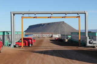
 Dundas Mt, framed by one of the many piping structures that go over the roads
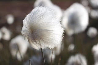
 really cool "puff plants" (thats not their real name...)
 view of the bay with ice bergs...working on better pictures :)

...ok next round will be people!

Photos!

After some downsizing and through an internet session at the Community center, I can finally upload some photos!  I apologize for the weird organization of them...my internet connection ends in 1 hour!
Ripple pattern in the flood plane of a river bed...I just think it looks really cool


 Hike north of Vortec, along N river towards the divide (aka the high point where the river begins from)
 The main source of N river seems to be a large snowfield, and what we thought to be the watershed divide.  This picture is near the bottom of the snowfield, the wider river in the center of the image was a slow moving slush river feeding into the fast moving (brown) main river channel.  It was an in interesting contrast in color, fluidity, movement and sound
 rock and ice, what much of our surroundings look like. The snowfield and ice sheet are in the background.
 The crew (Lu, Laura, Kyla and Markus) walking back from the divide.  The hills on the left make up the terminal moraine of the ice sheet.
 "Ice Cliff" sample site.  The equipment is for filtering water for DNA and RNA analysis; Markus is in the background collecting a 20L carboy of water that flows out of the ice tunnel.  This water probably originates as surface melt and cut down through the ice, and out the bottom, here, where we sample it.
 ice cliffs and surface melt water falls to the right of the above sampling site
 The Ice Cliffs have to be at least 100 feet tall... maybe more.  They are hidden behind a terminal moraine (aka really big rock pile) that you have to hike over... My first time hiking there was a really fantastic experience :  The landscape appears to be sloping rock piles and snow until you hike up a small pass, and get around the moraine... suddenly a mile long stretch of 100ft high ice cliffs appear with waterfalls cascading down the face.
 Another striking pattern on the ice cliffs.  It almost looks like an aerial photo of rivers over sand, but its made by surface melt coming down the cliff face.
 one of the larger waterfalls at the ice cliffs
 ice cave/tunnel/chute that we collect water from (Ice cliff site)
 Ice Caves (not to be confused with Ice cliffs!) along a river.  basically a river cutting through a  semi-permanent (I think?) snow/ice pack
 mud layered on rocks in the river flood plain by the ice caves
 biggest ice cave!
 Kyla and Markus measuring river discharge
Sample site: Vortec.  The rocks in the foreground are a sandstone that preserved symmetrical ripple marks, indicating that at one point there was a beach with waves that sculpted theripple marks in sand, before it was lithified (turned into rock!).  The background is the ice cliff above where we sample North river, the funny "m" shape in the cliff was sculpted by water.  Rock are constantly falling off the ice cliff and dropping into the water at this site.
 Old Tunnel into the permafrost that used to be useful for studying permafrost ice, until...
 ...the tunnel just filled in with a really thick plug of ice.  oops!
 Ice ramp!  This was made to drive trucks onto the ice sheet so they could get to camp century, a base carved into the ice!  The ice camp is not maintained anymore, and the ice ramp has caved in (the big rift you can see in the pic!)
 a moulin (ice sheet river) that we sampled.
 lake with icebergs that sits at the edge of the ice sheet
more of the lake!

Monday, July 25, 2011

Industrial, yet remote, July 23, 2011 (Day 3)


There are no locks here.  You leave the car keys in the ignition and building doors are closed with massive metal hatches.  It’s like some weird industrial utopia…contradictory?  Fundamentally, yes.  But here in Thule it seems like a fitting description.  All of Thule and the surrounding land (not covered by ice!) is open tundra.  Thule Air Base lies in a valley.  To the North and South, Thule is bound by ridges; to the west is North Star Bay and to the East are glaciers and the edge of the ice sheet.  All piping is above ground and the buildings are raised since the ground is permafrost.  Within minutes of walking you are in open tundra.  Industrial, peaceful and safe, all at the same time.  Very strange.

I’ve been going on evening runs to serve a dual purpose: learn the surrounding land and make myself tired enough to sleep in spite of the sunlight.  I ran north from our flat top (aka building 353, they have flat roofs) and up North mountain.  On my way out of town I saw three black Arctic foxes playing on pipes at the edge of town.  They were small, cat like, and ridiculously cute.  I continued up the road to the ridge of North Mt. and found myself at the top of massive basalt cliffs overlooking the bay, Dundas Village and Dundas mountain.  For those of you in Seattle, these cliffs are somewhat like Vantage, WA;  though not quite as columnar and incredibly chossy.  The road I took faded out and I continued on, cross country, along the cliff’s rim.  At this point I had traversed far from any roads and decided to take the direct, off-road route south, down North Mountain and back to Thule.  In my off-road adventure I was more worried about tripping on thin black wires that crisscross the entire slope than unstable rocks and loose dirt!  There is wiring, piping and remnants of human activity everywhere.  At first glance the surrounding land seems raw and untainted.   On foot, up close, the Thule Air Base “network”, both past and present, is clear.  I imagined what would happen if I accidently kicked one of the wires… maybe a satellite would shut down, or some alarm system would go off.  I have no idea how far I ran, with the open landscape I find it difficult to gauge distances. 

Thus far I have yet to see a bit of tundra free of human impact.  Trash, random building materials and sifted rock piles are everywhere.  It doesn’t seem trashed per se… just  thoroughly explored…
Dundas village, both old and new, are north of Thule.  “New” Dundas village seems like a misnomer.  The buildings have bold green, yellow and red exteriors but are mostly abandoned.  Their windows are broken out, the rooms are gutted, the doors are left open and the paint is chipping.  The spaces, however, must have been very homey and livable in their prime.  Near the center of the town there are two sled dog corpses, their harness are attached and their tales are still fluffy and soft looking.  Its eerie, as though this place was abandoned rapidly, or something tragic happened.  According to some researchers who have been to other small towns, seeing animal corpses in a small Greenlandic village is not abnormal.  Old Dundas village is a collection of remnants from a very old settlement.  One hut, made of wood boards and insulated with peat, still stands.  I have yet to learn the history of these villages and hope to make it to the small exhibit describing them.  

Some interesting facts I have learned:
The landfill is located on the bay.  Seepage from the landfill is draining into and contaminating North Star Bay.  They are currently moving massive rocks and boulders to cover the landfill and construct a barrier between the landfill and bay.  

There is an undetonated nuclear bomb in North Star Bay.  http://en.wikipedia.org/wiki/1968_Thule_Air_Base_B-52_crash

The Top of the World (TOW) club, the only bar on the base, is currently closed because a guy bit someone … strange, maybe true, maybe a tall tale J

And for reference, Dundas Mt. is a mesa on a peninsula, North of Thule…Working on photos and maps!